CHICAGO – A powerful storm system blasted through portions of the Plains and Upper Midwest on Wednesday, triggering at least a dozen Tornado Warnings and putting communities south of Chicago on alert for powerful thunderstorms.
The severe weather event was not as extensive as the outbreak that claimed the lives of at least 43 people last week from the Southern Plains through the South, but nearly 50 million residents were in an increased risk zone for severe weather.
Cities such as Chicago and Indianapolis were among those under threat, along with Peoria, Decatur and Champaign.
Gary, Indiana saw most of the significant damage as winds estimated to be at least 75 mph rolled through just after the rush hour, causing trees to fall and damage to homes.
“The City of Gary confirms that residents reported the sighting of a funnel cloud near 21st Avenue and Hendricks in Gary on March 19th. Multiple homes and businesses have reported significant wind damage, with flooding as well as numerous trees and limbs down throughout the affected area. Emergency response teams are on-site, actively assisting residents who have been impacted by the storm,” the city said during the initial hours of the clean-up.
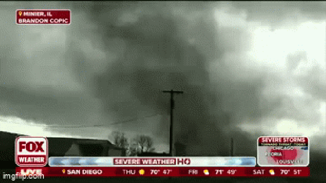
A tornado in Stafford, Illinois seen by FOX Weather’s Brandon Copic on March 19, 2025.
(FOX Weather)
HOW TO WATCH FOX WEATHER
The FOX Forecast Center said that indicators such as “dirty rain” and the sighting of several “gustnadoes” suggested that the day was not shaping up to be a record-breaking event. However, that did not stop reports of severe weather from pouring in.
“Gustnadoes” are simply swirls of dust from strong winds that race out ahead of a thunderstorm’s intense downdraft but can produce damage that is equivalent to a bonafide EF-0 or EF-1 twister.
FOX Weather Exclusive Storm Tracker Brandon Copic spotted one of the many vortexes near Stanford, Illinois, on Wednesday afternoon as a line of tornado-warned storms charged across the state southeast of Peoria.
Areas such as around Hammond, Indiana, and Chicago Heights were even put under a Tornado Warning, for what was a radar-indicated tornado.

A video complication from March 19 shows snow, wind and thundersnow in Nebraska during a winter storm.
The first round of extreme weather developed earlier on Wednesday across portions of Nebraska and Iowa, bringing snow, blizzard conditions and even thundersnow.
Power outages were rising throughout the day in Nebraska, Kansas and Iowa as blizzard conditions continued into Wednesday night. A 74 mph wind gust was reported in Lincoln.
Hail accumulations along Interstate 72 were also notable, with several crashes reported as the ice covered roadways, as if they had been through a blizzard.
National Weather Service offices across Illinois received reports of hail the size of pennies and quarters falling, which coated some grassy areas.
BUZZ WORDS YOU COULD HEAR DURING SEVERE WEATHER